Bristol sits on a complex geological boundary where Carboniferous Limestone of the Mendips meets the Triassic Mercia Mudstone and the Pennant Sandstone that underpins much of the city centre. This transitional geology, cut through by the steep Avon Gorge, creates sharp lateral velocity contrasts that conventional borehole investigations often miss. A seismic tomography survey maps these subsurface interfaces by measuring P-wave and S-wave travel times from surface sources to geophone arrays, processing the data through iterative inversion algorithms to produce a continuous 2D or 3D velocity model. We run both refraction and reflection acquisition depending on target depth and resolution, always following BS 5930:2015+A1:2020 for ground investigation and BS EN 1997-2 for geotechnical design. When the target is bedrock rippability beneath a proposed warehouse in Avonmouth or fault detection under a city-centre deep excavation, the velocity gradients derived from tomography give engineers a quantitative basis for design decisions that borehole logs alone cannot provide.
Seismic velocity models reduce the positional uncertainty of bedrock by mapping continuous interfaces rather than interpolating between scattered borehole points.
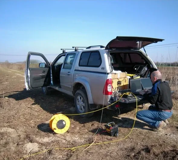
How we work
Local ground factors
A velocity model built from insufficient ray coverage will misplace a limestone pinnacle or a mudstone trough by several metres, and nobody discovers the error until the pile refuses 3 metres higher than the design anticipated or an excavation hits rock where none was predicted. In Bristol, the greatest risk is failing to account for buried channels of the Avon's paleo-course — sediment-filled depressions that produce velocity inversions invisible to standard refraction interpretation. These hidden features require careful first-break analysis paired with reflection processing to detect the low-velocity layer beneath a higher-velocity cap. The second risk is misinterpreting a weathered top-of-rock as competent bearing stratum; P-wave velocities below 1,200 m/s in limestone or 800 m/s in sandstone typically indicate a weathered zone that must be removed or bypassed. We cross-reference every tomographic inversion against the geological memoir of the British Geological Survey sheet 264 (Bristol) and, where possible, against physical samples to avoid mistaking a seismic artifact for a lithological boundary.
Relevant standards
BS 5930:2015+A1:2020 — Code of practice for ground investigations, BS EN 1997-2:2007 (Eurocode 7) — Ground investigation and testing, ASTM D5777-18 — Standard Guide for Using the Seismic Refraction Method, ASTM D7128-18 — Standard Guide for Using the Seismic Reflection Method
Related services
Seismic Refraction Tomography
Designed for bedrock profiling, rippability assessment, and mapping the overburden-bedrock interface to depths of 30 to 60 metres. We use a 48-channel array with 2–5 m geophone spacing and multiple shot points to achieve dense ray coverage. The tomographic inversion produces a P-wave velocity model from which we interpret lithology, fracture density, and weathering grade — critical for foundation design on the variable Carboniferous Limestone and Pennant Sandstone formations across the Bristol area.
Seismic Reflection Profiling
Applied when the target exceeds the depth limit of refraction, such as mapping fault zones beneath proposed deep excavations or identifying karst features below 60 metres in the limestone. We use a 48-channel spread with 10–14 Hz geophones and a CMP (common mid-point) acquisition geometry, processing through standard NMO correction, stacking, and time migration. The resulting section resolves stratigraphic boundaries and structural discontinuities that control groundwater flow and excavation stability.
Typical parameters
Common questions
What depth can seismic refraction achieve on a typical Bristol site?
For a standard 48-channel spread with 5-metre geophone spacing and a 10 kg sledgehammer source, we typically image the top 25 to 30 metres of the subsurface. Extending the spread to 120 metres with a weight drop or seismic gun increases penetration to 50 or 60 metres in competent limestone. The key variable is the velocity structure; soft alluvium in the Avon floodplain attenuates energy rapidly, while the dense Pennant Sandstone transmits seismic waves efficiently and allows deeper imaging with the same source energy.
How does seismic tomography compare to boreholes for bedrock mapping?
Boreholes give a point measurement at the drill location, while tomography provides a continuous cross-section between and beyond borehole positions. The two methods are complementary: we use borehole logs to calibrate the velocity-to-lithology conversion, and the tomographic model to interpolate bedrock depth between boreholes with far greater confidence than linear interpolation. For sites with irregular rockhead — common where the Mercia Mudstone overlies eroded Carboniferous Limestone — this combination reduces the risk of construction surprises substantially.
Does the tidal Avon affect seismic survey results?
Yes, the Avon has a tidal range exceeding 13 metres, and the resulting fluctuation in pore saturation within near-surface alluvium and made ground can shift P-wave velocities by 200 to 400 m/s between high and low tide. We schedule seismic surveys around low tide where possible and apply moisture-corrected velocity models during processing to separate lithological velocity contrasts from pore-fluid effects. This is standard practice we have refined over many Bristol projects along the Floating Harbour and Avonmouth areas.
What is the typical cost of a seismic tomography survey in Bristol?
For a typical Bristol site, seismic refraction tomography with a 48-channel spread covering a 100 to 150-metre profile line costs between £1,980 and £4,210 depending on the number of shot points, depth of investigation required, and site access conditions. Reflection profiling with CMP acquisition is at the upper end of this range due to the higher shot density and more intensive processing. Each quotation is project-specific and includes acquisition, processing, interpretation, and a BS 5930-compliant report.
Can you detect solution features and voids in the Carboniferous Limestone?
Seismic tomography can identify zones of anomalously low velocity that may correspond to solution-widened fractures, clay-filled fissures, or air-filled voids in the limestone. The detection threshold depends on feature size relative to the seismic wavelength; with 100 Hz dominant frequency and 2,500 m/s background velocity, the wavelength is 25 metres, and a feature must be at least one-quarter wavelength (6 metres) to produce a resolvable anomaly. For smaller features, we recommend combining tomography with resistivity profiling to cross-validate the interpretation. More info.